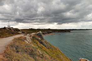
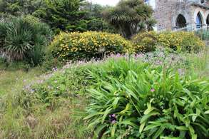
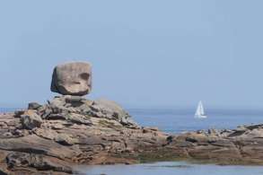
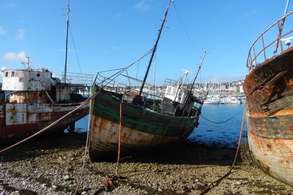
Wilde kust - Bretagne

Le Mont-Saint-Michel
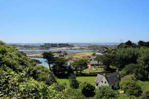
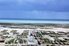
Le Mont-Saint-MichelThis route starts at Mont-Saint-Michel. If you want to know more about this special rock, also check out the last day of the camper route Wild Past - Normandy. The first destination of this camper route is Saint-Malo. By driving a short distance inland, you will come across several characteristic farmhouses built of granite. The first menhir (upright stone monolith) is also located along this route; you will encounter many more. The D155 along the coast offers a beautiful view of the mudflats and the oyster farms. You can park at various places along the road to take a look.

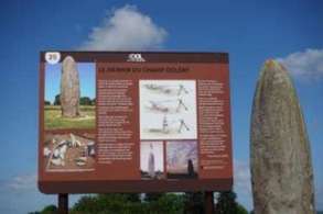
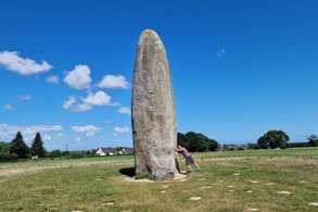
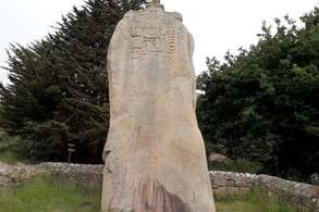
Menhir de Champ-Dolent
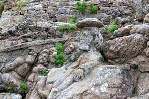
This stone dates from the Neolithic period. The typically Breton stones remain a mystery even to scientists. You can park along the road.
Mont-Dol
The 65-meter-high Mont Dol suddenly emerges from the otherwise flat landscape. In the distant past, it was a cult site of the Celts. The parking lot is located 600 meters from the turnoff. You are not allowed to go any further up with a camper, but the short walk to the top is rewarded with a magnificent view over the surrounding fields. Address: Chemin du Pavilon Coordinates: 48.56926, -1.76812 Another parking lot: Rue d'Eglise Saint Pierre Coordinates: 48.56948, -1.76447
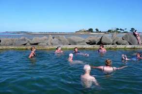
Cancale
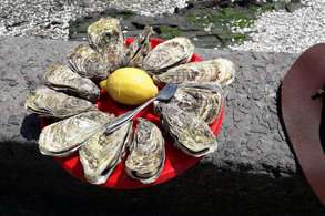
Cancale is a lively little town. Fishermen once departed from here by sailing ship to Newfoundland. Now, it thrives on oyster farming. At low tide, you can see the vast oyster beds. Using flat boats pulled by tractors, the fishermen bring in the harvest. There are two paid camper parking areas: Aire de Camping Car La Ville Ballet Area Sosta Camper Cancale (this one is not listed on Campercontact and is located close to the other camper site) Coordinates: 48.66972, -1.86562 It is a short walk (with some elevation changes) to the village.

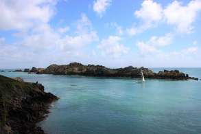
Pointe du Grouin
This cape is located approximately 5 km north of Cancale and offers a beautiful view of the impressive Île des Landes bird sanctuary.
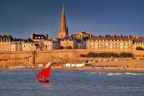
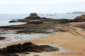
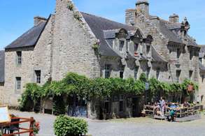
Saint-Malo
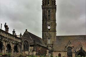
Saint-MaloToday you will stay near the city of Saint-Malo. Walk through the city and experience its history by visiting the many impressive museums. You can also go to Rothéneuf, where the Rochers Sculptées are located. These are various stone sculptures of mythical figures that were carved out of the rocks around 1900. Saint-Malo is well worth a visit. The city is situated on a granite outcrop, and most houses are built of granite. As a result, the old ‘ville close’ (walled city) can appear grey and invincible. That this is an illusion became apparent in 1944 when the city was 80% destroyed by an Allied bombing raid. Using the rubble, the ‘ville close’ was rebuilt in the style of the 18th century. You can take a beautiful walk along the city walls. The Cathédral Saint-Vincent was not reopened until 1964 after the bombing. Saint-Malo has a turbulent history, much of which can still be found in the two museums the city boasts: the Musée d’Éthnographie du Pays Malouin and the Musée d’Histoire de la Ville.
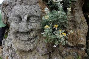
Les Rochers sculptés
In Rothéneuf lie the Rochers Sculptées, a fascinating group of sculptures carved into the rocks by Abbé Fouré. After a conflict with the church, he was removed from office and retired to a simple house on the coast. Over a period of about 20 years, he carved some 300 mythical figures—such as saints, animals, and demons—into the rocks above the sea. You can visit them and literally clamber among these figures. It is a truly remarkable sight.
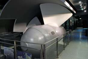
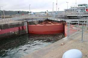
Usine marémotrice de la Rance
The tidal power plant on the River Rance was put into operation in 1966. It is an impressive feat of engineering that supplies electricity to approximately 223,000 inhabitants. In the discovery room inside the dam, you will find, among other things, a full-size turbine. The tidal range here reaches up to 13 meters. There is a parking lot across from the plant. Address: Route du Barrage, La Richardais Coordinates: 48.61741, -2.02882
Ploubazlanec
PloubazlanecToday you are staying in Ploubazlanec and can take the ferry to Île de Bréhat. Several ferries depart daily, and the crossing takes only ten minutes. The boats sail to the island from Pointe de l’Arcouest. Île de Bréhat is car-free and, with a length of 3.5 km and a width of 1.5 km, is perfect for exploring on foot. You can also rent bicycles there, but due to the many walkers on the narrow, winding paths, this is less recommended. For those who do not wish to walk, a small train runs across the island. Thanks to the mild climate, unique plants such as oleanders, mimosa, and agave grow there. In the center lies the main town, Le Bourg, with a charming square full of terraces and restaurants.
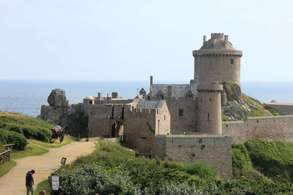
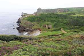
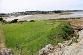
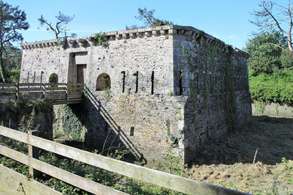
Fort la Latte
The oldest parts of the uniquely situated Fort La Latte — such as the moat, the keep, and the drawbridge — probably date from the 10th century. In the remaining parts of the fort, you can see various architectural styles that have been applied in fortification since then. The famous fortifications builder Vauban, one of the most important in French history, is responsible for the star-shaped ground plan of this fort.
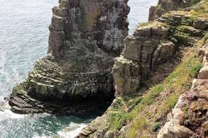
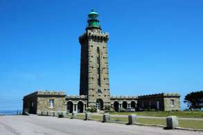
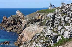
Cap Fréhel
Cap Fréhel is absolutely the most beautiful headland in Brittany. Populated by herring gulls, guillemots, cormorants, and puffins, the headland, with its rust-brown rock, stands out beautifully against the blue sea. Along the Sentier des Douaniers, the path formerly used by customs, you can enjoy a lovely walk and breathtaking views. The lighthouses were built in 1650 and renovated in 1950.
Étables-sur-Mer
Just before the Chapelle de Notre-Dame-de-l’Espérance in Étables-sur-Mer, the ‘Sentier des Douaniers’ walking path runs along the D786, a beautiful route along the coast. This path was formerly used by customs officers who monitored the coastline. The route runs between Plage des Godelins and Plage des Moulins. You can find a nice picnic spot at the coordinates: 48.636594, -2.826820 Parking lot at the D786 Coordinates: 48.63111, -2.82298
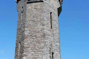
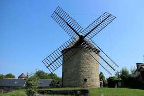
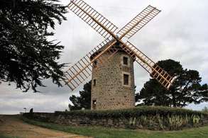
Saint-Quay-Portrieux
The Saint-Quay-Portrieux mill is characteristic and expertly restored. You can park along the route. Address: D786, Saint-Quay-Portrieux Coordinates: 48.65162, -2.84258
Chapelle de Kermaria-an-Isquit
The Chapel of Kermaria-an-Iskuit in Plouha dates back to the 13th century and was founded by the crusader Henry d’Avaugour after he had safely returned to his estate. In this ‘Chapel of Mary Restoring Health’, you will find impressive 15th-century frescoes depicting a danse macabre. In this dance of death, a pope, knight, emperor, and child, among others, dance together with Death — a remarkable and intriguing scene. There is a large car park where you can enjoy a peaceful picnic. Pay close attention to the opening hours, as the chapel is often closed in the afternoon. Address: D21 15, Plouha Coordinates: 48.68517, -2.97561 It adds 2 × 3.5 km to the route (round trip).
Abbaye de Beauport
This Romanesque abbey is one of the most beautiful in Brittany. The church has fallen into an impressive ruin, but of the monastic buildings, you can still visit the chapter house, the refectory, the cloisters, and a storehouse, among others. Both are located along the route. The abbey is often closed between 12:30 and 14:00. Therefore, please check the opening hours online in advance for the day you wish to visit the abbey. Abbey address: Chemin de l'Abbaye 7, Paimpol Coordinates: 48.76777, -3.01965 Parking (coordinates): 48.76788, -3.02122
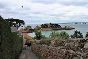
Île-de-Bréhat
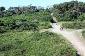
You arrive at the Port-Clos harbor by ferry, where you can immediately start a walk, have a cup of coffee first, or rent a bicycle. When walking on Île de Bréhat, you can see all the island's highlights via the 9.5-kilometer coastal path. However, it is also worthwhile to occasionally take a smaller path so that you walk closer to the coast and discover even more. Moreover, at low tide, you can walk sections along the seabed. It can get muddy due to the silt, so waterproof walking shoes are recommended. Soon after the start of your walk, you will come across the first sights. Close to the harbor lies the citadel, which now houses a glassblowing workshop. After that, you pass a small lake with a dike dating from 1633, where the photogenic Moulin du Birlot stands, a tidal watermill. It only operates when the sea level is average (about 6 hours a day), because the mill is submerged at high tide and has no water in the reservoir at low tide. If you walk uphill a little way here, you will reach the Chapelle Saint-Michel, where you have a beautiful view of the sea and the many small islands. Next, you reach the northern part of the island, where the landscape becomes more rugged. The northwest coast is dotted with enormous rocks of pink granite. At high tide, the waves crash against the rocks, creating an impressive spectacle. At low tide, you can walk around the rock formations and even climb on them. At the Paon lighthouse, at the northernmost point of the island, you have a view of both the pink granite coast and the jagged, grey rocks on the other side. You can walk back towards the ferry via the east side in about an hour and a half. In good weather, a stop at Plage de Guerzido, the island's only sandy beach, is certainly worthwhile. Flower Island Île de Bréhat consists of two parts connected by a bridge. The northern part is the most rugged. Due to the mild climate, Mediterranean vegetation grows there, and flowers bloom all year round. It is not without reason that the island is also called île aux fleurs.
Saint-Pol-de-Léon
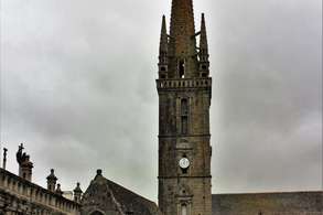
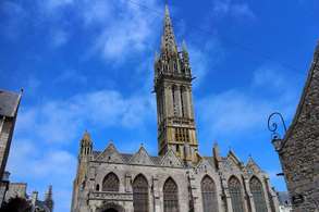
Saint-Pol-de-LéonToday you can leave your camper behind and discover Saint-Pol-de-Léon. Walk to the quay, settle down at one of the cozy restaurants, and admire the impressive cathedral. You can also take a walk to the small peninsula of Îlot Sainte-Anne. Saint-Pol-de-Léon is located on the Baie de Morlaix. Here, too, the difference between high and low tide is clearly visible. It is nice to sit on the quay and watch the water slowly return when the tide comes in again. You will find various cozy restaurants along the waterfront. The city also has an impressive cathedral, the Cathédrale Saint-Paul-Aurélien, which is certainly worth a visit.
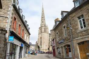
Tréguier (Côtes-d'Armor)
Tréguier invites you for a peaceful stroll. Half-timbered houses and stately mansions stand in the narrow streets surrounding the magnificent cathedral. In the past, Tréguier played an important role as a religious and cultural center. The tomb of the famous Saint Yves is located in the former cathedral of Saint Tugdual. This church dates from the 14th and 15th centuries and is a fine example of medieval Gothic architecture. Address: 1 Place du Général Leclerc, 22220 Tréguier Coordinates: 48.78768, -3.23113 You will find the parking lot on the right side of the D70, immediately to the right after the bridge. It is about a 10-minute walk to the cathedral, with an elevation difference of 27 meters over 550 meters (approximately a 5% incline). Address: Place du Général de Gaulle Coordinates: 48.78842, -3.22554
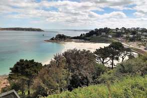
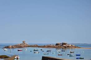
Trégastel
The seaside resort of Trégastel was founded in 1880 and is considered one of the places with the most beautiful beaches on the Côte de Granite Rose. And rightly so: the beaches here are stunning, and the pinkish-red rock formations make the landscape particularly special. The aquarium introduces you to the inhabitants of the seas around Brittany, from the deep sea to the mudflats. For the best view of the rocks, you can park at the aquarium, about 1 km from the D788. Parking address: Boulevard du Coz Pors 34, Trégastel Coordinates: 48.83214, -3.51214
Menhir de Saint-Uzec
The Menhir of Saint-Uzec is an 8-meter-high upright stone. This menhir was decorated with Christian symbols in the late 17th century. Follow the signs towards Menhir of Saint-Uzec. Turn left onto Route du Menhir from the D21; from there, it is another 550 meters to the location. It is most convenient to drive back to the D21 via the same road. Address: Route du Menhir 40, Pleumeur-Bodou Coordinates: 48.78878, -3.54472
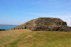
Cairn de Barnenez
The Cairn de Barnenez is one of the most important prehistoric structures in Brittany and also the largest megalithic mausoleum in Europe. It is a burial monument dating from 4600 BC. Address: Barnenez ar Sant 220, Plouezoc'h Coordinates: 48.66695, -3.85678 The parking lot is located 100 meters from the entrance.
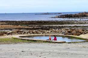
Îlot Sainte-Anne
You can walk along the promenade to the small peninsula of Îlot Sainte-Anne and climb the hill. Further along the pier, you will find a diving school. On the beach, there are two natural swimming pools that fill up at high tide.
Camaret-sur-Mer
Camaret-sur-MerToday you have time to discover the Île de Crozon peninsula, where Camaret-sur-Mer is located. You can do this on foot, by bike, and/or by camper.
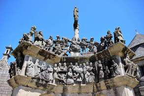
Calvaire de Saint-Thégonnec
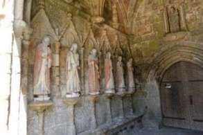
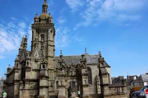
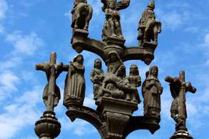
In Saint-Thégonnec, you encounter the first of the many walled church grounds. The calvary at this church is particularly beautiful, partly due to the rivalry that arose between Guimiliau and Saint-Thégonnec. One of the figures, an executioner's assistant with a moustache and beard, bears a striking resemblance to the Protestant French King Henry IV. The ossuary is a gem, featuring a depiction of the Holy Sepulchre in the crypt. Address: Avenue de Park an Iliz, Saint-Thégonnec Coordinates: 48.52224, -3.94594
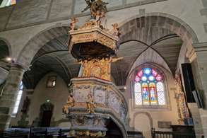
Guimiliau
It is clear that Guimiliau has won the race against Saint-Thégonnec when it comes to the interior. The portico is carved from granite and depicts scenes from the Old and New Testaments. Inside, the many statues, the imposing organ, and especially the beautifully carved oak baptismal font are overwhelming. Outside, the Calvary, with 200 figures in 25 scenes, forms a kind of story that you can ‘read’. Really take the time to appreciate this. Church grounds address: 1 Rue de l'Église, 29400 Guimiliau Coordinates: 48.48833, -3.99792
Commana
You can park behind the Église Saint-Derrien in Commana to visit the richly decorated 17th-century church. This parish enclosure features a triumphal arch with an image of the chained Jesus. Address: Place de la Mairie 7, Commana Coordinates: 48.41383, -3.95548
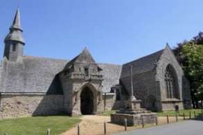
Sizun (Bretagne)
The 1590 triumphal arch of this parish enclosure is very special. The church, Église Saint-Suliau, is also certainly worth a visit. The parking lot is located nearby. Address: Rue de l'Argoat 2-283, Sizun Coordinates: 48.40571, -4.07837
Bretonse zeevruchten
For the true seafood lover, restaurant Les Viviers de Térénez is located right by the route on the D791. Address: Terenez, 29590 Rosnoën, France Coordinates: 48.28080, -4.25793
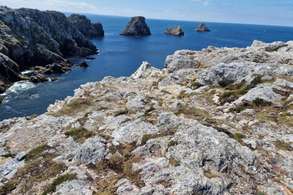
Île de Crozon
The Presqu’Île de Crozon (peninsula) is a rugged part of Brittany with high cliffs and, in many places, views of the Brest harbor. The area was once made accessible to tourism by automobile pioneer Armand Peugeot. The dune landscape, the beaches, and the narrow roads invite you to walk and cycle. Camaret-sur-Mer has an atmospheric harbor with a protective breakwater, on which stand the Tour Vauban and the Chapelle Notre-Dame-de-Rocamadour. The peninsula is ideal for exploring, both by bicycle and by camper. A beautiful route takes you past various special places, such as the harbor of Camaret and the Tour Vauban, Fort du Petit Gouin, the Semaphore du Toulinguet, the Manoir de Coecilian of Saint-Pol-Roux, the Alignements de Lagatjar, the Musée Mémorial de la Bataille de l’Atlantique, and the Pointe de Penhir on the D8. A walk along the coast is also worthwhile. You walk past impressive cliffs, flowering plants, and viewpoints towards, among other places, Îlot du Diable. Here you enjoy sweeping vistas of the sea and the rugged Breton landscape.
Alignements de Lagatjar
In 2500 BC, Camaret was a religious site. In 1776, a sacred site with approximately 600 megalithic monuments was discovered here. Of these, 143 have been re-erected. Address: 53B Rue Saint-Pol Roux, 29570 Camaret-sur-Mer Coordinates: 48.27345, -4.60948
La pointe de Pen Hir
The Pointe de Penhir is located approximately 70 meters above sea level. Below the cape lies a group of boulders known as the ‘Tas de Pois’ (Pile of Peas), which is clearly visible at low tide. On the cliff stands a monument in honor of all the Bretons of the Free French. Here, too, you will find a beautiful coastal walking path. Address: D8, Camaret-sur-Mer Coordinates: 48.25854, -4.62152
Quimper
QuimperBefore leaving the Presqu’Île de Crozon, you can first follow the ring road around the peninsula. After all, today’s route is only about 80 kilometers. The region you drive through today is closely connected to Cornwall in England and is therefore called Cornouaille. Via the striking hill of Menez-Hom and atmospheric Locronan, you end up in Quimper today.
Pointe Espagnols
The tip of the peninsula is called Pointe des Espagnols. Here you can enjoy a beautiful view, and the short detour to get there is a lovely route to drive. Address: Parking, 29570 Roscanvel Coordinates: 48.33954, -4.53791
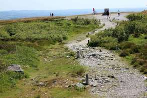
Ménez-Hom
The Ménez-Hom is a bare, rounded mountain 330 meters high, from where you have a magnificent view over the Baie de Douarnenez. It is one of the most beautiful viewpoints in Brittany. The car park is located about 6 km from the route. From there, it is a short walk to the summit. Address: D83, Dinéault Coordinates: 48.21887, -4.23641
Locronan (Finistère)
The historic center of the small town of Locronan consists of car-free alleys and a charming square with houses dating from the 16th to 18th centuries. The town owes its name to the Irish monk Ronan, who lived here in the 6th century. His tomb is located in the Chapelle du Pénity, and from the chapel there is a passage to the Église Saint-Ronan, dating from the mid-15th century. Director Roman Polanski filmed his movie Tess in Locronan. Address: D63, Locronan Coordinates: 48.09834, -4.20843 There is a good paid parking lot about 6 km from the route. Coordinates: 48.09669, -4.21195
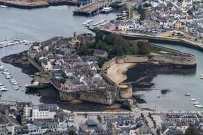
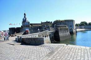
Concarneau
Ville Close is a walled city on a small island in the mouth of the Moros. Its history dates back to the 10th century, when a priory stood here. Today, the granite houses mainly house souvenir shops, restaurants, and cafes. Although it can be touristy, it is certainly worth a visit. Ville Close address: Rue Vauban, 29900 Concarneau Coordinates: 47.87180, -3.91613 Parking address: Avenue de la Gare 105, Concarneau Coordinates: 47.87856, -3.92047
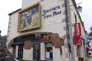
Pont-Aven
Pont-Aven is an artists' town on the Aven river. In the late 19th century, many painters came to this place, and the Pont-Aven School emerged. They were drawn to the romantic surroundings and captured daily life, often with residents in traditional costumes. The most famous painter was Gauguin. His painting *Dancing Breton Girls* now adorns the packaging of the famous galettes (cookies) from Pont-Aven. You can buy these cookies in the village, as well as at the Traou Mad factory. You can find the campervan site / parking at: Address: Rue Saint-Guénolé 4, Pont-Aven Coordinates: 47.85666, -3.75277 It is about a 10-minute walk to the center. Coordinates: 47.85372, -3.74372
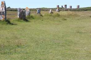
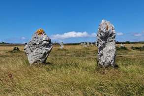
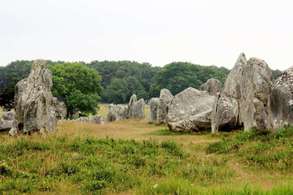
Rue du Ménec
Many prehistoric stones can be found around Carnac, including the Alignements de Carnac on the Rue du Ménec. This special place is now protected by a fence to preserve the site, but remains impressive to see. Around 7,000 objects can be admired in the Musée de Préhistoire. If you are interested in prehistory, this is highly recommended. Address: Rue du Ménec, Carnac Coordinates: 47.59159, -3.08299
Locmariaquer
LocmariaquerVisit the Gulf of Morbihan from Locmariaquer today and discover one of the most beautiful bays in the world. Here you can enjoy wonderful walks or bike rides across the many islets and fully appreciate the nature and the view of the water.
Golfe du Morbihan - Vannes agglomération
The Gulf of Morbihan — ‘Mor-Bihan’ means small sea — is an inland sea and belongs to the club of the most beautiful bays in the world. Countless small islands lie in the bay, some inhabited, others only by birds. Île aux Moines is the largest island. Thanks to the mild climate, orange and lemon trees grow here, as well as mimosa and camellias. ‘Quer’ means village and ‘loc’ means holy, so Locmariaquer stands for ‘village of the Holy Mary’. If you want to explore the peninsula by bicycle — highly recommended — and want to go to the village, follow the signs for ‘Le Bourg’. Here you will find a charming little harbor and lovely terraces.

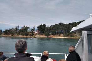
Boottocht op de Golfe du Morbihan
You can take a boat trip on the Golfe du Morbihan. Drive to Port-Blanc near Larmor-Baden, where you board the boat. After a cruise, you arrive at Île aux Moines, where you can explore the island on foot or by bicycle. Bicycles are available for rent here. In the village, you will find cozy terraces and restaurants, ideal for a relaxed lunch.
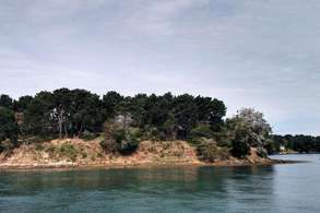
Île-aux-Moines
As soon as you arrive on Île aux Moines, you can rent bicycles to explore the island. Of course, you can also choose to do everything on foot. Please note that shops, such as the bakery for a tasty sandwich, are often closed at lunchtime. Also, pay close attention to the return ferry times; you can find these on the information boards on site.
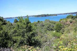
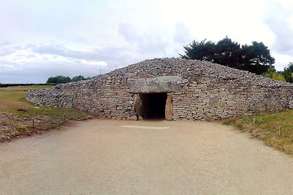
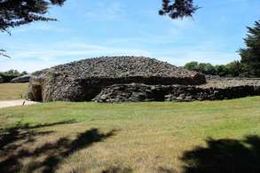
Table des Marchand
La Table des Marchands is located near Locmariaquer. This tomb from the Late Stone Age (4000–3400 BC) is one of the many impressive megaliths in this region. Address: Route de Kerlogonan, 56740 Locmariaquer Coordinates: 47.571700, -2.951314